6522 Five Forks Road
Stuart, VA 24171
Contact: Patrick County Chamber of Commerce
Email: patcchamber@embarqmail.com
Website: www.patrickchamber.com
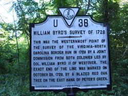
"This VA historical marker is the Westernmost point of the survey of the Virginia-North Carolina border run in 1728 by a joint commission from both colonies led by Colonel William Byrd, II of Westover." Historical Marker U 36
"The exact end of the line was marked on October 2, at a blazed red oak tree on the East bank of Peters Creek in Patrick County, VA".
Later in history, Peter Jefferson, father of President Thomas Jefferson continued the survey of the State line between Virginia and North Carolina
This marker is located on Five Forks Road. Directions: Follow Rt. 8 South of Stuart, VA. Just past intersection of Rt. 103 turn right on Five Forks Road and follow it to the NC line.
Just off the road in the gully, is a rock cement monument, which acknowledges the original pile of rocks left identifying where William Byrd stopped surveying.
Photos by Tom Bishop
References:
www.Virginiaplaces.org/boundaries
“They crossed Matrimony Creek ("called so by an unfortunate married man, because it was exceedingly noisy and impetuous"),14 and pushed on until they ran out of forage for the horses and wild game for the men. By October 26, 1728, the surveyors' had made their last blaze, on a red oak near Peters Creek (a tributary of the Dan River in modern Patrick County).�
“Byrd was so impressed by the quality of the land along the border, he soon obtained a grant and had William Mayo, one of the Virginia surveyors in 1728, mark the limits of his 20,000 acres where the Dan River crosses into Virginia. (Mayo also was one of the surveyors in 1736 for the Fairfax Grant, and Byrd was one of the colony's commissioners for that effort.)�
http://www2.vcdh.virginia.edu/lewisandclark/students/projects/adventurers/ncvaborder.html
".....Joshua Fry and Peter Jefferson were commissioned to extend the border line between Virginia and North Carolina in 1749. William Byrd drew Fry and Jefferson worked with the two surveyors from appointed from North Carolina, Daniel Weldon and William Churton (Frye, 8). Together, they added to a 1728 map drafted by William Byrd and William Mayo, surveying border from the Atlantic Ocean to Peter's Creek in Patrick County Virginia, a little further west from where Rt. 8 crosses the border today. Invaluble to the expedition were Jefferson's copies of Mayo's map from the original survey (Hickish, 137). The four surveyors extended the boundary from Peter's Creek 90 miles due west to Steep Rock Creek, just southeast of present day Damascus, Virginia. During their travels, Fry and Jefferson also took the opportunity to explore the countryside, and survey lands they held through the Loyal Land Company."
More Photos (click to enlarge):


Patrick County Virginia Border and Route 660

Stokes County Border-North Carolina
Get news from Patrick County Chamber of Commerce about programs, events and so much more.
Get news from Patrick County Chamber of Commerce about programs, events and so much more.